Great Scott!
The diary of a Londoner’s 1913 solo cycling tour of Scotland
In the early 20th century, a cycling holiday offered unprecedented freedom to young men. And while the motor car overtook the bicycle as the most fashionable way to travel, dedicated cyclists and cycling clubs grew in number.
One Saturday evening in late July 1913, 27-year-old Charles Scott from Palmers Green set off for his fortnight’s summer holiday. He was equipped with a map of Scotland but had no grand plan. At Kings Cross station, he carried his bike on to a steam train to Northumberland, left Darlington station at 3.45am and began cycling through the twilight towards the Scottish border.
His 14-day adventure took him around 1,000-plus miles of moors, coast and mountainside. The experience was so exhilarating and challenging that he was inspired to create a guide containing map, diary, photographs and tips so other cyclists could follow in his tyre tracks. Discovered among donations to a church bookshop, it is published here, 110 years later.
-
![]()
Charles Scott's handmade photograph album
-
![]()
"Real Scotch"
-
![]()
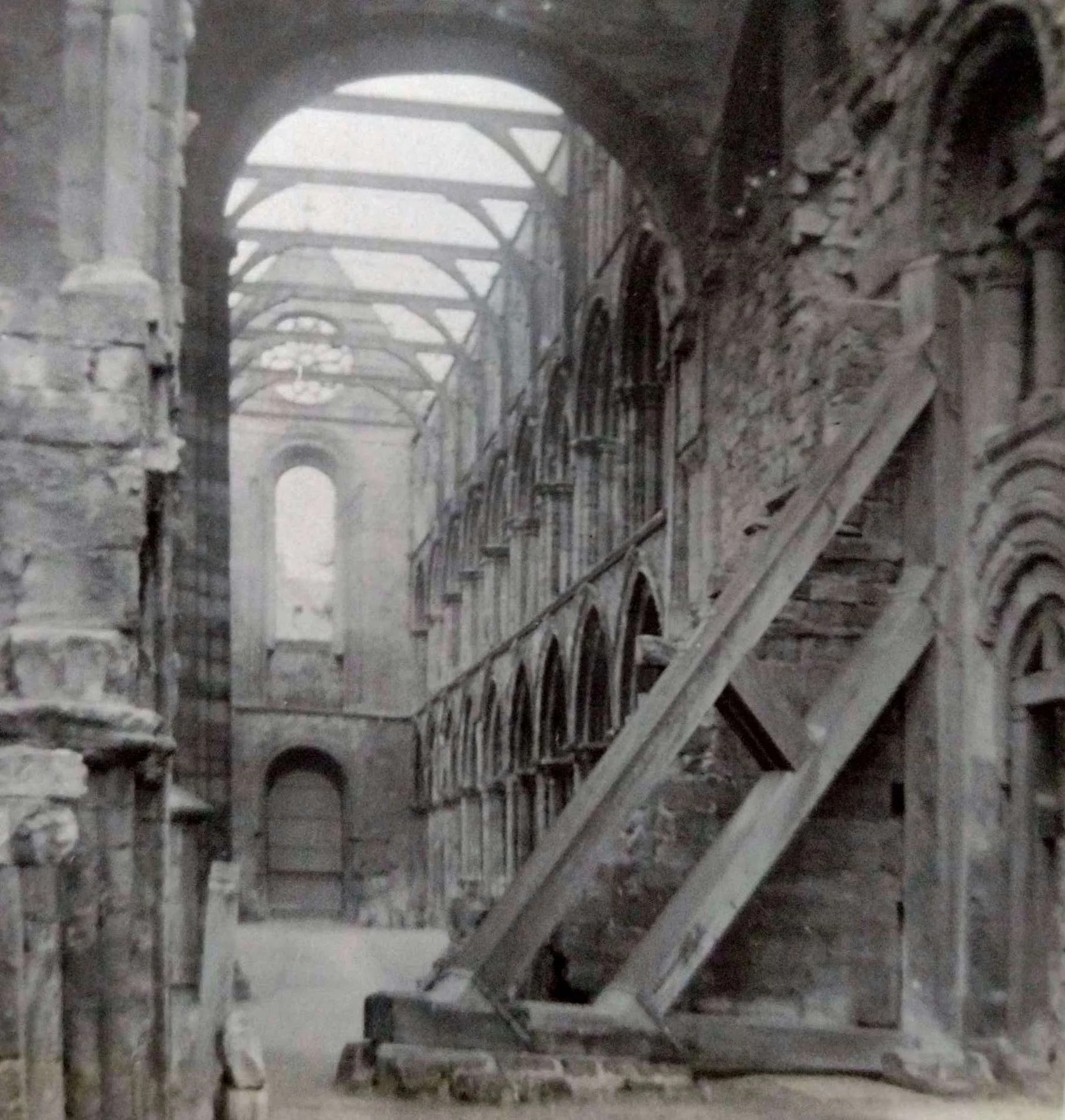
"Jedburgh Abbey. Interior"
-
![]()
"Potarch Bridge. Near Aboyne"
-
![]()
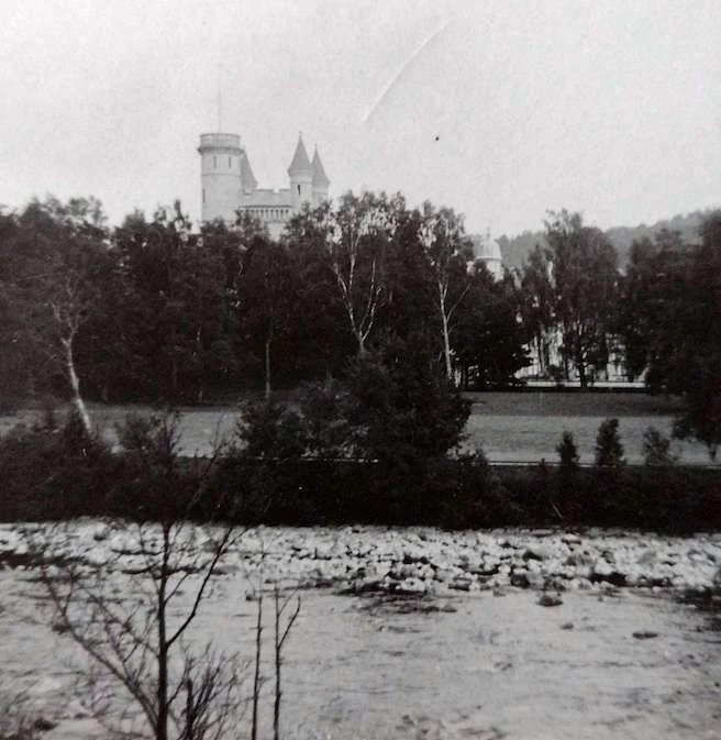
"Balmoral Castle"
-
![]()
"Braemar"
-
![]()
"The road between Braemar and Blair Athol, Glen Tilt"
-
![]()
"The road between Braemar and Blair Athol. River Dee"
-
![]()
"Carrbridge. The Old Bridge"
-
![]()
"Inverness. The Castle"
-
![]()
"Fort Augustus. View from road above"
-
![]()
"Fort Augustus"


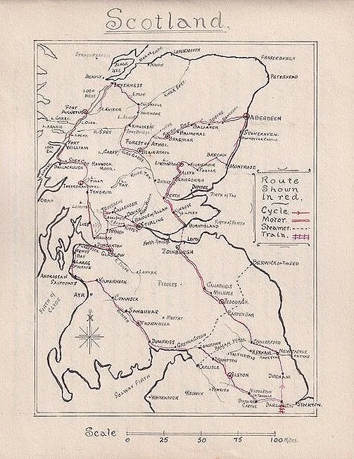
Scotland
A fortnight’s tour from Darlington, July-August 1913. By CFS.
Having cycled north as far as Scarborough some years ago & seen the sights of Cambridge, Peterboro, Lincoln and York, I decided to penetrate further north for my holidays & as I did not make up my mind to tour in this direction until a day or two previously I was unable to plan my tour beforehand.
Having obtained one of Bartholomew’s maps of Scotland, I caught the 9.55 train Friday evening from Kings Cross to Darlington where I arrived at 3.45am. Mounting my cycle I reached and was exploring Durham at an early hour, while waiting to get some breakfast. The great attraction was St Cuthbert’s glorious Cathedral, perhaps the finest & best situation in Europe. It is a gem both for its architecture and its natural surroundings overlooking the river Wear. The view from Prebends Bridge, where the following lines are carved in oak, are worth going miles to see:
“Grey towers of Durham, yet well I love thy mixed and massive piles.
Half Church of God, half castle ‘gainst the Scot;
And long to roam these venerable aisles
With records of deeds long since forgot.”
The castle contains a fine oak staircase and a curious old chapel in the basement.
After getting the human engine in good order, I pushed on to Newcastle, a dirty commercial town that I was glad to have behind me. Here I decided to see a part of the Roman Wall which was built by Antoninus between Forth & Clyde, AD140, to keep out the barbarian Picts of the north, so took the western turnpike to Chollerford. The road was pleasantly undulating and for the most part runs along the top of the wall. The last mile or two descends very steeply to the North Tyne and the picturesque George Inn where they make the traveller very
“I started on the long climb between bare and gloomy hills up to Carter Bar (1,250ft) where one crosses the Cheviots to enter Scotland”
comfortable. At Chesters the next village was the Roman Station of Cilernum which guarded the passage of the Tyne. The abutments of the bridge formed of massive blocks of stone may still be seen which show the thoroughness of the Romans’ work. From here I recrossed the river and turned north again along a very hilly road through Barrasford to Woodburn. After tea I started on the long climb between bare and gloomy hills up to Carter Bar (1250ft) where one crosses the Cheviots to enter Scotland. It was a lovely view from the summit with the sun setting behind the distant hills and the glorious coast down a good road to Jedburgh was well worth the climb up.
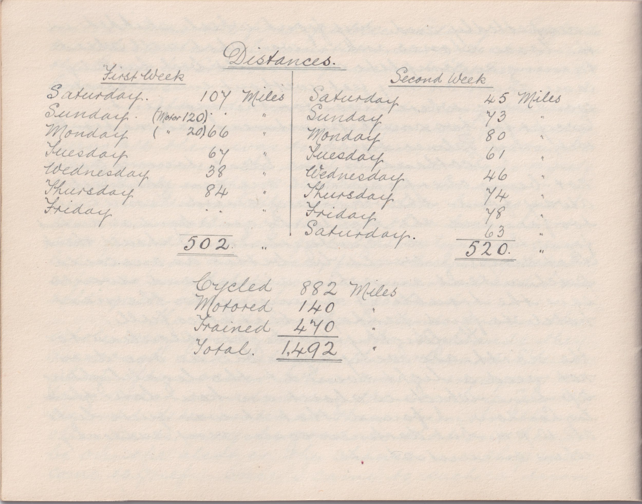
107 miles.
Sunday: Roxburghshire, Edinburgh - and the perils of motoring
I awoke somewhat early despite the fact that I did not go to bed Friday night. so started to ramble round Jedburgh, the County Town of Roxburghshire. The Abbey founded in 1118 occupied an elevated position on the river Jed. It was battered by the artillery of the Earl of Surrey during the reign of Henry VIII but it is in good preservation. The Nave displays an array of pillars and arches and has a fine Norman West Door.
After breakfast I was soon seated in the car of a friend whom I had met the previous evening and we quickly entered Melrose. Its chief attraction is the Abbey, which owing to the day being Sunday was closed so we had to be content with an outside view. From here we made straight for Edinburgh whose attractions are too well known to need any description here. We left rather hurriedly to catch the 1 'o’c boat from Granton to Burntisland (6/- car, 5d each person).
Kinross was our next place but a back tyre now troubled us by tearing the valve out of two tubes in a few miles & in the end we had to send for a new tube & fit another tyre. While we were waiting for the new tube to come from Kinross some good people from a house near by very kindly invited us to tea, which was very welcome, after which we were soon in going order. [We quickly] passed Loch Leven with the island Castle, from whence Mary Queen of Scots made her famous escape, & through the lovely Glen Farg to the Ancient City of Perth.
After crossing the Tay we made for Blairgowrie, crossed the river Ericht to Alyth & thence by narrow but lovely lanes up to Lintrathen Castle which was our destination for the night.
About 120 miles
Monday: two castles, a tale of the Scottish ‘crown jewels’ and granite-packed Aberdeen
The Castle is situated on a hill amid a forest of pines and firs, overlooking the beautiful Loch Lintrathen. After being shown over the Castle & part of the grounds where I was given a sprig of white heather for luck, the car was ready and we hurried through Kirriemuir to Forfar. Here I had to leave my friend who was returning to the Castle for three months' shooting.
I then followed the eastern road through Brechin to Montrose, a well built town with wide streets situated at the mouth of the South Esk. The High Street contains statues of Joseph Hume and Sir Robert Peel. I now kept to the coast road to Stonehaven. The cliff scenery here is very fine but Dunottar Castle is the chief place of interest. The ruins cover about three acres upon a bold rock, washed by the sea on three sides and on the land side there is a deep chasm which defends the approach. The Scottish regalia were deposited here, and during the siege the garrison were forced to surrender by hunger, but not before their precious charge had been secretly removed & buried under the pulpit at Kinneff Church. The castle was also used at one time as a state prison.
Aberdeen (“The Granite City”) was my next resting place. It is situated chiefly between the rivers Dee & Don at their confluence with the German Ocean. The city is filled with creditable specimens of its chief ware - the polished granite stones famous for their durability & beauty. Union Street, its principal thoroughfare, contains most of the public buildings, the Old Cross and a statue of the last Duke of Gordon close by. A little further along there are also statues of Queen Victoria and of Prince Albert. The East & West churches in a cemetery are separated from the street by a fine Ionic facade. Above the gardens is a bronze statue of Burns and by the Denburn Viaduct is a statue of Wallace. Marischal College is a massive granite structure with a tower 100ft high.
Motor 20
Cycle 66
86 miles
Tuesday: “modern” Balmoral and a swim in the royal river
My road now went up to the Dee Valley & soon enters fine Highland scenery through Banchory and past Potarch Bridge to Aboyne. The Highland Gathering is held here on the village green, the most important of such meetings. There is a suspension bridge across the Dee and an obelisk on a hilltop to the memory of the late Marquis of Huntley. After passing the small but pretty Loch Dinnet where some volunteers were making a pontoon bridge. the road enters Ballater (660ft) where the Hill of Oaks (Craigendarroch) is a specially noticeable feature from any point of view. At the farmhouse of Ballatrich (or Ballaterach) Byron lived. From Ballater the road now somewhat loose, still keeps to the north bank of the Dee, crossing Gairn Water & skirting the base of Craig Yougie?? (the Rock of Firs). Opposite to the remains of a pristine Highland clachan, called The Micras, stands Abergeldie Castle, one of the Royal shooting lodges. A little beyond in the pretty village of Crathie and a little farther across the river is seen Balmoral
“It is a great temptation to bathe in the cool waters for a bird or two may see you but the odds are no mortal will be within a mile”
Castle. It is quite a modern building dating from 1856 and is the private property of the Royal Family. Formerly it belonged to the Farquharsons. The road runs through lovely forests with the river sparkling in the sunlight between the trees and it is a great temptation to bathe in the cool waters for a bird or two may see you but the odds are no mortal will be within a mile. At any rate I was not disturbed. Feeling refreshed I rode on to Inver & crossed the bridge of Invercauld thrown over a rocky strait of the river. Passing the base of Craig Gluny??? the straith opens showing Invercauld House (Colonel Farquharson), said to be the most beautifully situation mansion on Deeside. About the centre of the straith is Mar’s Castle, a modern erection and immediately beyond is the elevated Castleton of Braemar, over 1000ft above the sea, ringed round by some of the loftiest mountains in Scotland.
67 miles
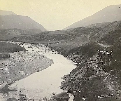
Wednesday: “the hardest day’s ‘ride’ I have ever done”
After crossing the turbulent Cluny which rushes down to join the Dee I kept south of the river to Linn of Dee where I crossed to the north bank by a bridge which was opened by Queen Victoria. The road now becomes very loose and rutty and in a mile or two is so bad that I was only able to keep seated for a few yards at a time & occasionally rode on the heather at the roadside. But worse was in store. The rivers were not bridged so I had to take off my shoes and wade across, which was no easy task with a cycle loaded with luggage. Presently I was unable to cycle at all as the track entirely disappeared.
After tramping some miles I came to a house surrounded by trees, a little off the track, so made enquiries of a keeper - who came towards me equipped with gun and teliscope [sic] as to which direction I had to go there being no sign whatever of a path, and was informed that I should have to foot about 20 more miles across the mountains before I regained anything that could designate a road.
“A keeper - who came towards me equipped with a gun - informed me that I should have to foot about 20 more miles across the mountains before I regained anything that could designate a road”
This is an enormous tract of wild mountains known as the deer forest of Atholl. It is estimated to contain several thousand deer and extends for nearby 100,000 acres, chiefly 1000 feet above the sea but the mountain tops average over 3000 feet. I travelled through stretches of bare moor where not even the hardy pine can grow, over bogs and swamps, & large areas of granite boulders where going was very slow. One cannot believe that such wild regions exist in one’s native country. Certainly I have never seen a more barren place in my wanderings. The keepers are not allowed to sell even mineral waters for fear of encouraging tourists & for themselves have to lay in a stock of provisions which will last at least six months, being practically prisoners during the winter. Well I expected wild scenery and it was here with a vengeance.
I was still fresh so pushed along guided by the sun. I crossed stream after stream. While the hours went by [I travelled] along a narrow mountain path with only room to walk while my cycle had to be carried or pushed & bumped over the rock-strewn heather & chiefly uphill. About 4o/c I left the Dee near its source having travelled up the river all the way from its mouth at Aberdeen. The track now crossed the Geldie & went down Glen Tilt, in places a mere ledge high up above the river.
I was now feeling tired & hungry to say nothing of a thirst as I had had nothing since breakfast. At 5.30o/c I came to a large rock covered with various things evidently laid for tea by a shepherd who may have gone down to the river for water, but I met nobody. The things were not very appetising, but in my hungry
“I managed to get astride for a few yards now and then, but a piece of rock hidden amongst the heather brought about my downfall many times until I was quite an expert at falling”
state they were a great temptation. However I got by them and soon reached the lovely Falls of Tarf, spanned by a suspension bridge from rock to rock. The track still kept by the Tilt between Ben Dear???? (3304ft) & Ben-y-Gloe (3671ft) but I had to tramp several more miles before I managed to get astride for a few yards now and then. [However] a piece of rock hidden amongst the heather brought about my downfall many times until I was quite an expert at falling. After many miles of this mode of travelling I had to pass through a pine forest, but still the track was hard to find & quite unrideable as the trees were laying across my way in confusion and had to be climbed over. There is a private road near here but His Grace has put up notices that cyclists & pedestrians must not use it except for a short distance where it was impossible to go anywhere else.
At last the road climbed over another hill & then descended very steeply with water channels running across. I was strongly advised to walk but I was too tired for that and knowing my steed I rode down bumping over the channels & arrived in Blair Atholl at about 8.30 o/c.
My first thoughts were for my inner self & I was not long getting outside of a good supper. I then made enquiries regarding a bed but found they could not accommodate me, so I tried the other hotel (there are only two) which was also full. They recommended me to try the Station Master but no luck. It was impossible to go on to the next place over the pass of Killiecrankie to Pitlochry, so with the help of several villagers I started a door to door search for a bed. Nothing more did I want to make me happy. About 10 o/c I secured one at a Sadlers shop & was soon in the land of dreams.
38 miles
This was the hardest day’s “ride” I have ever done.
Thursday: towards Aviemore with a ride alongside the UK’s highest railway
I had a very comfortable night & slept well past my time. After breakfast which I had to have at the hotel, I turned west, passing near Blair Castle and the Bruar Falls. The road passes along Glen Garry? & the railway follows the road, but for the most part on the other side of the glen, uphill and through bare & inhospitable country thinly populated. The mountains in these parts are appropriated to deer, which adds to one’s difficulties. Men who own them do not
“ I saw immense pine forests and then Aviemoor where one gets beautiful glimpses of the blue mountains of the Cairngorm Range”
favour the inquisitive strangers prowling on their heights. The glens can only be entered through the gates which lead firstly to the luxurious shooting lodges built for the sport of the landlords’ guests or summer tenants and one has to be thankful to get a view of the mountain tops. The morning was foggy so little was to be observed except the bleak features of the surrounding hills which form the great forest of Drumouchter, until the upper end of Loch Garry appears on the left, near the shooting lodge of Dalnaspidal. In a few more miles I reached the summit of Drumouchter Pass (1500ft) side by side with the highest railroad in the British Isles.
After passing Badenoch Boar (2432ft) on the left and the end of Loch Ericht I entered Dalwhinnie. Passing through Glen Truim and over the Spey Bridge I coasted nearly the whole way to Kingussie.
The landscape again became beautifully diversified along the course of the swift Spey to Loch Insh. Next the extremely picturesque Loch Alvie came in sight & the Torr of Alvie on the right of which is a cairn erected to the memory of the Highland soldiers who fell at Waterloo & a monument to the Dukes of Gordon. A little further on the right is seen the artificial mound called Downe of Rothiemurchus and the immense pine forests of the same name and then Aviemoor where one gets beautiful glimpses of the blue mountains of the Cairngorm Range, towering to a height of from 3500 to 4000 feet.
The road now passes through Cambridge where the old bridge crossing the Spey near a deep pool looks very picturesque. Then the road climbs gradually upwards till it agains a height of over 1300 feet. Here I punctured for the first time. Then I had a delightful descent past Loch Moy to the valley of the Nairn, rose again & then down to Inverness arriving about 10pm.
84 miles.
Friday: in and around Inverness, the Capital of the Highlands
As I wished to meet some friends who were arriving by train on the morrow, I decided to spend the day in & around the “Capital of the Highlands”.
The Council Chamber of the Town Hall contains some fine local portraits & outside is the Town Cross in the base of which is inserted the Palladium of Inverness, Clach-na-cudainn (Stone of the Tubbs), so called from having served as a resting place for the women carrying water from the river. On an eminence nearby is the Castle, a modern building from which one gets a very fine view of the surrounding country & the river below, crossed by a number of fine chain bridges. In front is a granite monument to Flora Macdonald, the heroine of Prince Charles, inscribed
“ ‘Mong hills that by richt his are
He roved a lonely stranger”
and a captured Russian cannon. On the opposite bank is the Cathedral, a modern building in the Decorated Gothic style. The walk along the Ness to the Islands is very pleasant. They are laid out as pleasure grounds where the shady arbours & numerous rustic bridges form a favourite resort of the Inverness folk & here I spent the evening at a fete. The Cemetery is quite unique, situated on the slopes of the Tom-na-Hurich (the hill of the fairies) and is beautifully laid out. from the summit one gets another lovely view. The battlefield of Culloden Moor is about six miles east of the town where by the roadside can be seen stones marking the burial trenches of the different clans and a memorial cairn marking the site of the last battle on British ground 17th??? April 1746.
xx miles
Saturday: coasting along the Caledonian canal
The morning I spent looking round the shops while waiting for my friends to arrive. In front of the Railway Station is the monument to the Camerons, who won their laurels in many a hard won battle to the “March of the Cameron Men”.
At mid-day I again mounted my cycle & made for the Caledonian Canal, which consists of a chain of salt & fresh water lakes extending from the German
“At the top of a hill with danger boards every few yards a grand view came into sight: clouds were breaking on the distant peaks of Ben Lue”
Ocean to the Atlantic. I followed the road along the south-east shore of Loch Ness which is the first of the chain. It is twenty miles in length & in many places is so deep (about 800ft) that it never freezes, the scenery throughout is perfect. About mid-way on the opposite side is the isolated peak of the Mealfourvonie, rising to a height of 2284ft. I was tempted to stay & explore the many beautiful glens & waterfalls but time would not allow.
Passing the Foyers Hotel the road left the loch & climbed up alongside the river Foyers to a very dangerous hill where there were danger-boards every few yards & past Loch Land & Glen Doe. A grand view now came into sight, in front the clouds were breaking on the distant peaks of Ben Lui etc & on the right was a lovely birds-eye view of Fort Augustus as I descended by a very steep & winding road to the Highland Village. After tea I decided to remain here until the morning, there not being time to get to Fort William before dark as I had intended.
There are seven locks here by which the steamers descend from Aberchalder to Loch Ness, similar to those at Inverness at the head of the loch. The fort built shortly after the rebellion of 1715 was sold to Lord Lovat in 1867 and is now converted into St Benedict’s College & Monastery. It makes a pretty view with its unrivalled surroundings.
45 miles
Scroll down to keep reading
-
![]()
"Well of Seven Heads. Loch Oich"
-
![]()
"Glencoe Pass. Evening"
-
![]()
"Arolui. Loch Lomond"
-
![]()
"Stirling. The Old Bridge"
-
![]()
"Stirling. Mar's Wark"
-
![]()
"The Trossachs. Loch Achray and Hotel"
-
![]()
"Glasgow. The Art Gallery"
-
![]()
"Largs"
-
![]()
"Gretna Green"
-
![]()
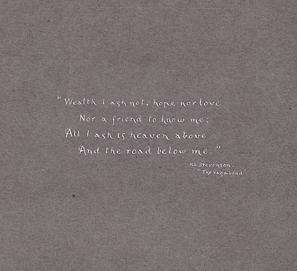
"Wealth I ask not..." RL Stevenson. The Vagabond


Although the guide is marked only CF Scott, an address has been handwritten along the spine so we were able to find the young author on the 1911 census: Charles Frank Scott, 27, who lived with his parents and younger sister Maud and worked as a stationer’s merchant. His job would given him the skills - or access to the skills - to hand-make the guide, which is precise in every detail.
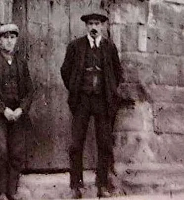
The photograph of Mar’s Wark, Stirling, shows a tall, strong, young man wearing the type of suit and cap typically sported by cyclists in the 1900s plus shiny bicycle clips. This could well be Charles Scott, posing next to a group of local men.
Sunday: the Great Glen - “70 miles sheer unadulterated beauty” - and into Glencoe
My road now crossed the river Oich & then along the western side of Loch Oich which is 4 miles long & over 100ft above sea level, the highest & smallest of the chain, passing the old ruins of Inverganny Castle, a former stronghold of the chief of Macdonell, burnt in the rebellion of 1745. On the roadside near the end of the loch there is a monument, “The Well of seven heads” which commemorates the summary vengeance inflicted by a former chief of Glengarry on the murderers of the Keppoch family. It is topped by their seven craven faces carved in stone and is inscribed with the tale of their wrongdoing in four languages. Soon the road crosses by the locks of Laggan to the eastern bank of Loch Lochy which is ten miles in length. There are innumerable water courses across the road which have to be ridden over very carefully. Leaving the loch the road crosses the Spin & along Strath Spean??, overlooked by the snow-flecked shoulders of Ben Nevis (4406) who presents to this side his noblest aspect & which is the highest mountain in the British Isles. The country is very sparsely populated, there being no village whatever in the 22 miles from Fort Augustus. The road now descended to Fort William which in old days was one of the keys to the Highlands, connected by military roads with Stirling and Inverness. The town is modern & not very interesting except for the surroundings so I pushed on along the shore of Loch Eil to Loch Linnhe.
This run through the Great Glen of Scotland is a stretch of about 70 miles of sheer unadulterated beauty. For miles & miles the road out from the precipitous side of the hills runs through forests of birch, spruce, fir, oak & rowan carpeted with luxuriant bracken.
My road now took an easterly direction & after tea at the Loch Leven Hotel, I hailed the ferryman & crossed Loch Leven to Ballachulish. It is only about 300ft wide here but owing to the strong current took quite 15 minutes to cross & was hard work for the ferryman.
As the bells were calling folk to church I started the climb up the famous Glencoe Pass, probably the wildest in Great Britain & the scene of the massacre of the Madonalds, one of the darkest in history. Here a crowd of mountains amassed together in wild confusion, conspicuous among them being the three
sisters, Faith, Hope & Charity. Some ruined huts by the roadside indicate the scene of the massacre commemorated by a cross to Ian MacDonald and his people at the lower end. And nearby is a mansion built by Lord Strathcona, now the owner of Glencoe, which till recently belonged to a descendant of the MacDonalds. Some five or six miles have to be walked to the head of the pass (1449ft) where the road passes under the peaks of Buachaille Etive 3129ft & ???? 3543ft on which were several patches of snow.
Near the top of the pass, I met some campers and knowing I was near a hotel I stayed to chat, so that it was dark before I started the run down. The road surface was terrible, simply a mass of loose stones & I was delayed still more by a nail in my back tyre. On reaching the Kingshouse Inn I found they could not give me accommodation so there was nothing to do but ride on to the next. It was now pitch dark & the road now passes over the dreary moor of Rannock, the greatest plain in Scotland covering some 400 square miles. This land was once covered by the Caledonian forest. Much caution must be observed if one should wander from the road for the surface is treacherous & into the miry moss one can quickly sink, to rise no more. Another walk of three miles to the top of Black Mount & then I descended for about nine miles. The road was awful and how I kept on the saddle at all is a mystery for I could not see where or over what I was going and occasionally came to a sudden stop when something extra large barred my way or I met some stray animal, perhaps a deer but it was too dark to distinguish. I had some trouble in finding the way but at last the road improved & passed through a forest, then I saw the waters of Loch Tulla and I knew I was nearing the Inveroran Hotel. Hearing footsteps I made enquiries of an unseen person and on lighting my lamp found it was close by. It was past 11o/c so I considered myself very fortunate in getting accommodation which was very good & as it was late I contented myself with some thirst medicin and turned into bed for a well earned rest.
73 miles.
Monday: the “bonny, bonny banks” of Loch Lomond and riding “gingerly” to Stirling
After a very comfortable night I arose and found that one window of my bedroom overlooked the loch whilst the other faced on to the road & in the distance could be seen the Black Mount deer forest which extends for some 80,000 acres. After breakfast (which included trout caught in a neighbouring stream by a guest) I did some slight repairs rendered necessary by the rough riding of the previous night. I then took the road to Bridge of Orchy & a long climb hemmed in by steep green mountains to Lyndrum, then down to the Crianlarich Hotel. Here I took the road to the right, down Falloch Glen to Ardlui a
“Words fail to describe this most lovely lake which requires a whole holiday spent on its shores to learn half its attractions”
t the head of Loch Lomond, which is only a narrow fjord at this end. It is the finest loch in Scotland, 20 miles long & varies from 60 to 600 feet in depth. The mountains rise up on both sides in rugged majesty, the chief being Ben Lomond 3192ft.
The road keeps along the bonny, bonny banks, it is very much cut up by motor traffic & covered with thick dust, but it is being remade & the corners rounded off & when finished will be one of the most popular drives in Scotland.
Passing the Tarbet Hotel & pier, I reached the pretty village of Luss where the loch opens out & is five miles broad at its widest and studded with thirty beautiful fir-clad islands. But words fail to describe this most lovely lake which requires a whole holiday spent on its shores to learn half its attractions. At Balloch at the foot of the loch the trains start for Dunbarton so I hurried east to Drepmen.???
Here I discovered that one blade of my front fork was broken, which had been the cause of my machine running badly all day, & was no doubt caused through riding over the rough Glencoe Pass. I tried to get it mended at a small cycle shop but they could not do it and not being able to get a train I decided to ride “gingerly” the intervening 20 miles to Stirling, the next place of any importance. I expected to be thrown over every minute, but the road had a very good surface and I safely arrived about 11.45pm to find all the hotels were closed. After good deal of ringing, I managed to wake somebody up and was in bed & asleep in a very few minutes.
80 miles.
Tuesday: Sightseeing by horse-drawn tram and the “tourist-overrun” Trossachs
Early in the morning I took the remains my “iron” to be repaired and after breakfast I made a tour of the chief places of interest assisted by what they are pleased to call a tramcar, a kind of lorry furnished with uncomfortable sets & drawn very leisurely by two horses which ought to have been boots or anything but horses. However I must be thankful as it saved walking.
Stirling is an interesting place in which to spend a few days, but my time was limited to a morning. It is built on an eminence above the river Forth, and was at one time an important fortress. There are still traces of the Wall of Antoninus (known as “Graham’s Dyke”) built by the Romans. The Castle, now the headquarters of the Argyll and Sutherland Highlanders, dates from the feudal period and is situated on a steep rock 340 feet above the vale below. The view from the battlements is very extensive, the Wallace monument on a steep-wooded hill being very prominent.
Mar’s Wark, the remains of a house built by the Earl of Mar, is supposed to have been built from the ruins of Cambuskenneth and for the sacrilege its founder was cut off before the work was finished. Its decorated architecture is of an ecclesiastical character. The parish church was erected in 1494 by James II and is painted Gothic in style, a type peculiar to Scotland. The coronation of James VI took place in the choir on the 29th July 1567.
My bicycle was now ready so I packed up & got astride about mid-day. My route lay to the north again to Bridge of Allan passing on the way the beautiful Old Bridge of Stirling which existed long before there was any bridge upon the Tay or any bridge of stone over the Forth so it thus made the gate between the north and south of Scotland. Here was fought the Battle of Stirling [Bridge] 13th Sept 1297 when the Scots under Wallace gained their first victory over the English. A little further along is the Wallace monument high up on the right. It is in the form of a lofty baronial tower 220 feet in height & contains memorials of other great Scotsmen. Here the road turned to the left and in another mile I was “on the banks of Allan Water” and the foot of the Ochil Hills. The roads here were being remade with tarmac but improved before reaching Doune on the river Leith. Nearby rise the towers of Murdoch of Albany’s stronghold, Doune Castle, roofless & ruinous but still a majestic pile. The road now follows the Leith to Callander at the foot of Ben Ledi (2875ft) & then leans to the left for the Trossachs along a shady avenue and by the northern shore of Loch Venacher. The scenery now grows eminently picturesque with Ben Venue (2393ft) ahead, Loch Achray on the left and the Trossachs Hotel to the right which although modern makes a pretty picture with the wooded slopes of Ben A’an (1750ft) as a background.
The place was overrun with coaches and tourists but motors are forbidden. Loch Katrine is a little further on, but I turned round the end of Loch Achray to a
"At a toll gate I was relieved of sixpence for the privilege of pushing my bicycle over a vile road on which it was impossible to ride”
toll gate where I was relieved of sixpence for the privilege of pushing my bicycle over a vile road on which it was impossible to ride, apart from the steepness. The lady became cross with me when I asked what I was charged toll for. She said it was to keep up the road, but as the surface appeared never to have been repaired I presumed she meant the gradient. At any rate I received plenty of instructions on how, when & where to ride. If a coach chanced to come my way I was to dismount and hide myself until it had safely passed and generally make myself scarce. I did not mind this but why have to pay for it?
Well, I had to climb & push for about four or five miles which took about as many hours and having gained the summit (1271ft) I rested to enjoy the splendid view and thought of the Scotsman who once boasted that his country could lick England for size any day, if it was only rolled flat. Mounting again I coasted down the other side at a pace which now & then made my hair stand on end as the road was rough and corners very frequent. Then a sharp pull up at the other toll gate to give up my pass & leaving the Trossachs I entered Aberfoyle at the base of Craigmore, down which I had just come.
The road now crossed the “infant Forth” here known as the Avon Dhu (Black Water) and in a few miles arrived at Drymen where I crossed the Stirling road along which I passed the previous evening and sped along a well made road and chiefly downhill to Glasgow.
61 miles
Wednesday: Glasgow’s shipyards, the Firth of Clyde and pesky midges
Glasgow is the most populous town in Scotland and is too much like London, but not so interesting so I did not stay very long. But as I spent the night in University Street near Kelvingrove Park it was necessary to pass the University which is situated on the top of Gilmore Hill above the park. It was designed by the late Sir Gilbert Scott in the Early English style and is surmounted by a central tower 300 feet in height. I also saw the magnificent building known as the Art Gallery & Museum which was opened in 1902 and originated in the balance of money over from the International Exhibition of 1888.
My way was now over ten miles of rough sets and tramlines along the north bank of the Clyde, past some of the largest and most famous shipbuilding yards in the world to the Erskine ferry where I crossed the river and followed the south bank.
This road is much more pleasant & in a short distance is seen across the river the basaltic mass of Dunbarton rock, the Gibraltar of Scotland, 240 feet high, on which is an ancient castle. Port Glasgow, the next place, is a dirty manufacturing town with rough cobbled streets overrun with trams which was
"At Greenock post office I received my first and only news from home and friends, so I decided to ride to a quiet spot where I could have an al fresco lunch on the sea shore and read the good news at leisure”
uninteresting except that the first British steamer was built here by Henry Bell & voyaged between Glasgow & Greenock at the then amazing rapidity of 5 miles an hour.
Greenock is another busy town which I was glad to have in the rear whose chief industry appeared to be shipbuilding. James Watt the inventor of the steam engine was born here in 1736. But the Post Office was the place that I made my way to, as I have received my first and only news from home and friends. As may be guessed it was a rather bulky packet, so I decided to ride past the suburb of Gourock to a quiet spot where I could have an al fresco lunch on the sea shore and read the good news at leisure undisturbed by the madding crowd.
After about three hours thus spent I followed the coast road along the Firth of Clyde through Inverkip to Winnipeg Bay, one of the points of embarkation for the Clyde pleasure steamers which although much advertised appear to be the only attractions. But it is a pretty road with views of the Isle of Bute across the Firth. Next I came to Largs, a pleasant seaside resort which contains two fine modern churches and is interesting as the scene of the battle where the Norwegian invaders were defeated in 1263 by Alexander III. I tried to fix up for the night here but owing to the regatta all hotels were more than full, so I pushed on for about three miles to Fairlie, a quiet little village where I was fortunate to secure the last bed, although it was still early. A little way inland is Kelburn Castle with a romantic glen and waterfall.
It is a pretty sight to watch the sun setting behind St Cumbrae and the more distant islands but my happiness was spoilt by a species of midge which I have not had the misfortune to meet with before, except in the evening near Inverness when I was mending a puncture. I believe they belong to the genus ceratopogon, they are so minute as to be barely visible and swarm to countless numbers causing terrible annoyance by their bites. Smoking does not seem to disperse them and the only thing to do is to keep on the move.
46 miles
Thursday: ports, resorts and pleasure steamers
I again kept to the coast road east Sea Mill to Ardrossan which is a considerable port with fine pleasure steamers plying in all directions. But together with its neighbours Saltcoats are only interesting as Glasgow seaside resorts. I now turned eastward, leaving the coast for Kilwinning, Kilmarnock and Mauchline where a “National Burns Memorial” recalls that this was the scene of the “Holy Faire” and other poems that Burns wrote while he was tenant of
“On the coast road, Androssan is a considerable port with fine pleasure steamers plying in all directions”
Mossgiel Farm, close to the town. Here I went some miles out of my way on the road to Ayr and had to return as I wanted the road through Cumnock & New Cumnock where the road passes down the well wooded Nith Valley through a country haunted with the memory of the Covenanters passing Sanquhar with its ruined castle. I intended to stay the night in Dumfries but as it was getting late I ended my day at Thornhill, a quiet old village composed chiefly of two wide streets crossing each other, with a monument in the centre. The place was very dull and unlit and did not boast even a picture palace so after a smoke I turned in to bed which, as is often the case in Scotland, was a hole in the wall.
74 miles
Friday: Robert Burns’ final home, Gretna Green, then across the border to Cumbria
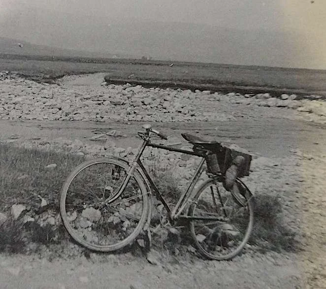
I continued down the Nith Valley to the ancient town of Dumfries. There is a monument to the memory of a Duke of Queensbury but the chief attractions are the humble home in which Robert Burns died and the beautiful remnant of Sweetheart Abbey which lies about eight miles to the south. I have turned south east to Annan where one gets a distant view of the Solway Firth, and so on to the little village of Gretna Green, at one time visited by so many English travellers who went no further into Scotland. In the old days Gretna Green being the first Scottish village reached on the high road, a blacksmith here was in the way of acting as witness to hasty vows often perhaps repented of at leisure.
I now crossed the boundary river Sark and made for Longtown and Brampton. Here I intended to explore the remainder of the Roman Wall but could not as time was getting short so continued along my road which climbs to a high altitude above the South Tyne which I followed to Alston, the highest marked town in England, built on a very steep hill.
It was my wish to get to Darlington but having again entered a wild mountainous region I thought it would be safer to stay here the night instead of travelling along an unknown road in the dark. I again had some difficulties in attaining a bedroom and only succeeded in getting a small lap-room tap room??? which according to the bill I believe I bought outright but could not bring it away with me.
78 miles
Saturday: the Pennines, County Durham and a unique piece of railway history
I got away early but slowly having to climb up to 2000 feet in a few miles between the peaks of Cross Fell (2900) and Knock Fell (2780) and others. The road runs over a moorland, the views being too great for a camera, then descends to the Tees Valley, passing the well known High Force Waterfall and Hotel where the Tees dashes over a 60ft cliff and runs down a canon of great beauty to Middleton in Teesdale.
After lunch, I had to walk some distance uphill past Romaldkirk and then had a fine run down to Barnard Castle. Having plenty of time to spare I spent several hours here looking round, but there is not much of interest except the Castle ruins & the old Market House. Mounting again I rode through country
“My front wheel skidded in the loose stones and I was shot well ahead turning a complete somersault but luckily came down on my feet without even a scratch wondering where I was”
rendered picturesque by the variety of landscape to Winston and Gainford - celebrated for its springs of mineral water - to Piercebridge ascending Earlbury Bank and passing Earlbury Hall on the left to the village of High Coniscliffe where there is a fine old church, St Edmunds, built on a tremendous rock of limestone. Not far from the river bank and from this eminence an entrancing picture of the valley of the Tees presents itself. A few more miles brought me to the Salutation and the busy commercial town of Darlington.
The Darlington and Stockton Railway, opened in 1825, was the first public railway in England on which steam locomotives were used, and in the Bank Top Station is preserved Stephenson’s No 1 Locomotive.
After dinner I whiled away the time looking in the numerous shops and generally seeing all there was to be seen, till midnight when I entered the station and made myself comfortable on the 12.23 train for London.
There is little more to relate but so far I have said nothing of the weather because it was fine the whole fortnight, only changing between fine and very fine which is unprecedented so far as my holidays are concerned and I am told quite exceptional in Scotland.
The roads in the Lowlands are on the whole very good but in the Highlands they are rough and hilly with awkward “S” turns which often occur when one is enjoying a long coast or admiring the scenery. Generally the road deteriorates at these turns although other parts may be good so that one has to be on
“Scotland is an ideal touring ground. Not being overpopulated one can get well away from the madding crowd - sometimes too far”
the alert or the chances are they will come to grief. Once I came to such a turn unexpectedly and my front wheel skidded in the loose stones and I was shot well ahead turning a complete somersault but luckily came down on my feet without even a scratch wondering where I was for the moment. Except for two small punctures I had no trouble with my Palmer tyres.
Scotland is an ideal touring ground. Not being overpopulated one can get well away from the madding crowd - sometimes too far - and the Highlands are about as distant from London as Switzerland. I should think that camping would be better as one could pitch a tent anywhere almost and would save the trouble of humping to the next hotel to find perhaps that it is full.
The lengthy twilights peculiar to the north are very agreeable as one does not need a light even at the legal lighting up time which is about an hour later than in London. I found that it was quite light at 10pm but darkness comes very suddenly when once it starts.
Published with the kind permission of Pearl and Jim Larner